
You're standing at the perfect viewpoint. The early morning mist is rising gently, there's a smell of Spring in the air. It's predawn, but you know what exposure you're going to need, and how long you'll be waiting for the first rays of sunlight. 20 minutes later you've got the shot, and are on your way home for coffee.
How often does that happen?
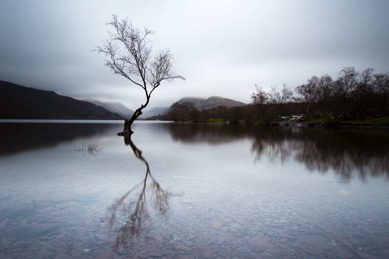
The lone tree of Llyn Padarn
My landscape photography adventures are usually less well executed. I might spend the previous day scouting for viewpoints. I will have checked the weather at the weekend, and have fingers crossed for clear skies, or cloudy skies, or mist, or rainbows or whatever it is I had planned.
However: if I find a good spot the weather is usually wrong. If I have a good spot and good weather my brain is too hungry/cold/tired to think through the best exposures. On the off chance it all comes together and I can make hyperfocal distance calculations on the fly, my hands will be too cold to change apertures with any degree of accuracy.
Until now.
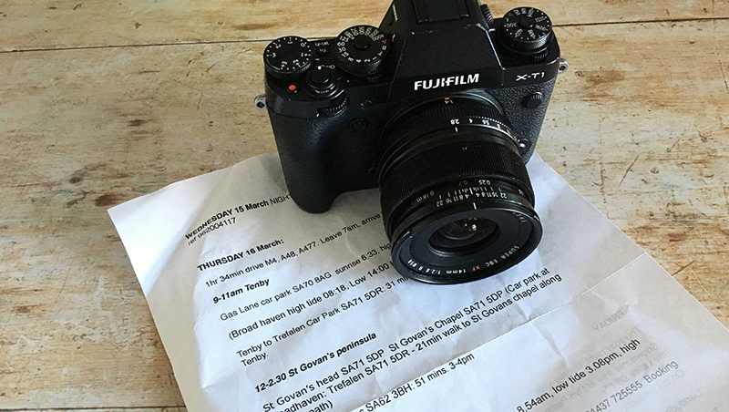
I had a quick trip round Wales last week which I can honestly say went like clockwork. I left nothing to chance at all. And while some might say that takes all the romance out of landscape photography, I say when you've only got 48 hours, every minute counts.
I did it all with apps. Forward planning, plus on the spot updates meant the only thing I had to contend with was local weather fluctuations.
1. Pre trip location scouting: 500px.com
If you only have a short time in a place, see what other people have done before you. As great as it is to spend a week exploring and stumbling on unique spots, most of us just don't have that luxury. I use 500px to find ideas for both areas (eg Pembrokeshire) and exact spots (eg Marloes Sands). 500px has an app as well, so you can take them with you on tour.
500px can be a bit intimidating, but any photo sharing site is good for getting ideas - Instagram, Flickr, Pinterest.
It can be tempting to try and replicate exactly the images you find. Try and avoid this temptation. It's unlikely you'll have the same weather and kit, and in any case, your landscape photography is your reaction to a place, not someone else's. Use these sites as a shortcut to good locations, but not for prescriptive shot lists.
FREE BEGINNER'S PHOTO LESSONS
I teach beginner's DSLR online, including landscape photography basics. The workshop is called A Year With My Camera and you can register here and get started today:

2. Route planning: Google street view
Be flexible, but have a plan. I used Google maps with Street View to narrow down exact locations, and the distances and times between them. I used it to get the postcodes of car parks nearby. I had an itinerary ready, but with alternatives if the weather changed.
3. Navigation: JOMO OS offline maps
Although the car's satnav will get me to where I need to be, I still like to have Ordnance Survey maps with me (and not dependent on wifi or having a phone signal) - for changes of plan and hiking. I use Jomo OS offline maps for this - they do all of GB's National Parks.
4. Weather: Met Office
The Met Office weather app was one of Google Play's top apps of the year 2016, and it's very user friendly. You can save locations, see weather a week ahead, and best of all, it has a rainfall map that you can scroll through for the next few hours to see how likely you are to get wet:


5. Tides: Met Office tide tables
You can get tide tables in plenty of places online, and there are many apps. But the good thing is, tide times don't change with the weather so you don't need to carry them with you so much. I use the UK's Met Office tide times website which I have saved as a shortcut to my phone's home screen.
6. Sunrise/sunset times: The Photographer's ephemeris
This little app is legendary. For starters it will tell you sunrise and sunset times all over the world. You can then visualise on a map which direction the sun will both rise and set. And the moon. You can overlay shadows and elevations. You can save locations. Don't leave home without it.
The people behind TPE have also launched 2 other apps that I haven't tried yet but which look interesting. Photo Transit, a field of view visualiser - see what can be captured by your choice of camera and lens before leave home. And Skyfire, to predict sunrise and sunset colours.
7. Hyperfocal distance: Photo pills
PhotoPills does some of the things that TPE does, so you could get away with just this one if you just want basic sunrise and sunset times. I use it mostly to calculate hyperfocal distances. You can dial in your camera and lens, and it will give you the hyperfocal distance, and the near/far planes of focus for every aperture.
The only thing I haven't found an app for is coffee on demand.
A year With My Camera
Join my free flagship online beginner's photography workshop here: